Peru - Maps and Plans
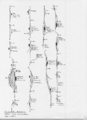
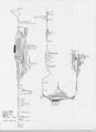
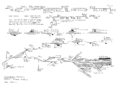
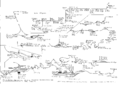
These diagrams of railways in Peru were drawn by and are © Stephen R.L. Phillips, F.R.I.C.S. They comprise schematic route maps, and track plans of all stations and other complex locations. Note they depict the railway as of 1999, so may now be out of date.
Ferrocarril Central Andino
The Ferrocarril Central Andino (FCCA) is a standard-gauge line, running from the port of Callao, via Lima, through the Andes to La Oroya and Huancayo. At La Oroya, there is a junction with the Ferrocarril Cerro de Pasco (FCCP). At Hauncayo, there is interchange with the narrow-gauge (3' = 914mm) Ferrocarril Huancayo - Huancavelica (FCHH).
-
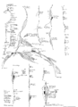
FCCA Callao - Lima
-
FCCA Lima - San Bartholomé
-
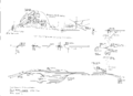
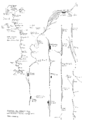
FCCA San Bartholomé - La Oroya
-
FCCA La Oroya - Huancayo
-
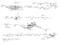
FCCP La Oroya - Cerro de Pasco
-
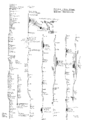
FCHH Huancayo - Huancavelica


Ferrocarril Sur
The Ferrocarril Sur is comprised of several connecting routes:
- standard gauge: Cusco - Juliaca, Puno - Juliaca - Arequipa, Arequipa - Matarani / Mollendo
- narrow gauge (3' = 914mm): Cusco - Machu Picchu - Hidroelectrico (formerly continued to Quillabamba)
-
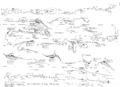
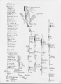
FCS (ng) Cusco - Machu Picchu - Hidroelectrico
-
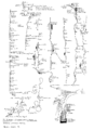
FCS Cusco - Combapata
-
FCS Tinta - Juliaca (excl.)
-
FCS Juliaca - Puno
-
FCS Juliaca (excl.) - Arequipa
-
FCS Arequipa (excl.) - Matarani / Mollendo


